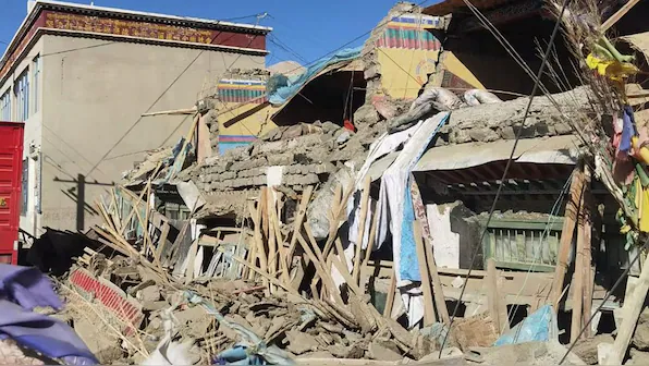
Powerful Earthquake in Nepal
Earthquake in Nepal: On January 7, 2025, a powerful 7.1 magnitude earthquake shook the Tibetan region near the Nepal border. The epicenter was located approximately 80 km north of Mount Everest, at a depth of 10 km beneath the surface. By evening, reports confirmed at least 95 fatalities and over 130 injuries in China, alongside widespread property destruction. The tremors were felt as far as Kathmandu, Nepal, and Kolkata, India. This earthquake highlights the seismic vulnerability of the Himalayan region and raises concerns about potential future disasters.
Epicenter and Local Impact
The quake’s epicenter was in Tingri County, Shigatse, Tibet, an area situated 4-5 km above sea level with a population of roughly 7,000. Renowned for its spiritual significance as the seat of the Panchen Lama, the region has now become a site of devastation. Local authorities have restricted tourist access in the aftermath of the disaster, a move further reinforced by the winter season’s typical decline in visitors. Hundreds of homes have been flattened, leaving the community grappling with severe infrastructure damage.
Seismic Activity in the Himalayan Region
The Himalayan region is a seismic hotspot due to the ongoing collision between the Indian and Eurasian tectonic plates. This tectonic interaction exerts immense stress along fault lines, frequently triggering earthquakes. The Indian plate continues to move northward at a rate of 60 mm per year, sustaining the region’s seismic activity. Historical records reveal that since 1950, over 21 earthquakes of magnitude 6 or higher have occurred within the Lhasa terrane, underscoring the area’s geological volatility.
Geological Significance and Concerns
The Lhasa terrane, a crucial geological fragment, played a significant role in this earthquake’s dynamics. It is also central to major construction projects, such as the world’s largest hydroelectric dam on the Yarlung Tsangpo River. This raises concerns about potential impacts on the river’s flow downstream into India, where it becomes the Brahmaputra. Known as the “third pole,” the Himalayan region holds immense freshwater reserves, making its geological stability a global concern.
Future Earthquake Risks in the Himalayas
Experts caution that the western Himalayas, stretching from the Hindu Kush to Arunachal Pradesh, remain highly susceptible to significant seismic events. The region is overdue for a major earthquake, possibly exceeding magnitude 8. Historical data shows that only two major earthquakes in the past 500 years have ruptured to the surface in this region, suggesting a dangerous accumulation of elastic energy along fault lines.
Understanding Tectonic Movements
Earthquakes are caused by movements along faults in the Earth’s crust, driven by the motion of tectonic plates. The Earth’s surface consists of 15 major and minor plates that are in constant motion. These plates can become stuck at their edges due to friction, and when stress surpasses this friction, energy is released as an earthquake. The convection currents beneath the Earth’s crust drive these movements, making the study of these mechanisms essential for predicting and mitigating future seismic risks.


