Introduction: Great Earthquake
In the remote Mishmi Hills, on August 15, 1950, the earth trembled violently. The epicenter lay hidden amidst lush forests, where the Indian Plate collided with the Eurasian Plate. This seismic marvel, with a staggering magnitude of 8.7, left an indelible mark on history.
Significance:
- The 1950 Assam–Tibet earthquake ranks among the ten strongest on record.
- It defied conventional wisdom, originating not from subduction zones but from continental collision.
Epicenter:
- The Mishmi Hills, nestled in the northeastern corner of India, bore the brunt.
- The ground shook, homes crumbled, and lives were forever altered.
Magnitude:
- At 8.7, it dwarfed other quakes, echoing across Assam and Tibet.
- The roar of nature’s fury reverberated through valleys and mountains.
Historical Context
Tectonic Setting
In the heart of the Himalayas, two colossal tectonic plates—the Indian Plate and the Eurasian Plate—engage in a slow-motion dance. Their convergence is not gentle; it’s a fierce collision that shapes the landscape over millions of years.
Collision Zone
- The Indian Plate, moving northward at a rate of several centimeters per year, meets the Eurasian Plate head-on.
- The collision zone spans from the northern plains of India to the lofty peaks of Tibet.
Thrust Faults and Mountain Building
- As the plates collide, immense pressure builds up along fault lines.
- Thrust faults play a pivotal role. These are fractures in the Earth’s crust where rocks are pushed upward and overlying layers are thrust forward.
- The Himalayas owe their grandeur to these thrust faults. Layers of ancient marine sediments, once at the bottom of an ancient ocean, now form the highest peaks on Earth.
The 1950 Assam–Tibet Earthquake
- On that fateful day in 1950, the accumulated strain along these fault lines reached a breaking point.
- The ground shook violently, releasing energy equivalent to thousands of atomic bombs.
- The Mishmi Hills, nestled in the northeastern corner of India, bore witness to this cataclysmic event.
The collision of continents, the relentless forces shaping mountains, and the seismic fury—all converge in the story of the 1950 Assam–Tibet earthquake.
The Catastrophic Event
Date and Time
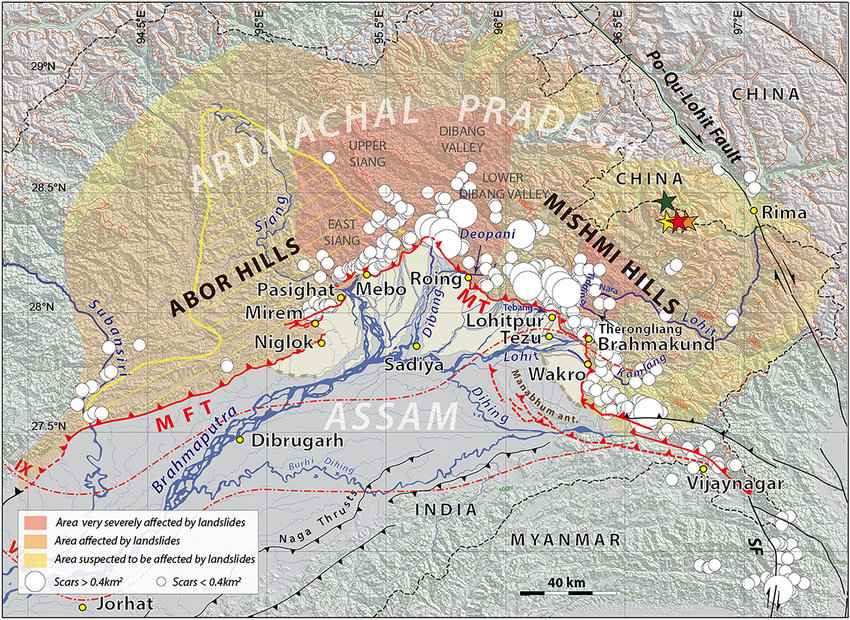
- On August 15, 1950, at precisely 7:39 pm IST, the earth convulsed violently.
- The epicenter lay hidden in the remote Mishmi Hills, where the Indian Plate collided with the Eurasian Plate.
Destruction in Assam (India) and Tibet (China)
- The ground trembled, buildings swayed, and chaos ensued.
- In Assam, homes crumbled, bridges collapsed, and lives were shattered.
- Across the border in Tibet, villages were obliterated, and ancient monasteries lay in ruins.
Human Toll
- The loss was staggering: approximately 4,800 lives were claimed by this seismic fury.
- Families were torn apart, communities devastated, and futures forever altered.
The 1950 Assam–Tibet earthquake remains etched in history—a somber reminder of nature’s immense power and our vulnerability.
Unconventional Origin: When Continents Collide
Contrast with Subduction-Related Earthquakes
- Most earthquakes occur at subduction zones, where one tectonic plate dives beneath another.
- These subduction quakes release energy as the descending plate grinds against the overriding plate.
The 1950 Assam–Tibet Earthquake
- This quake defied convention—it didn’t happen in a subduction zone.
- Instead, it resulted from the collision of the Indian Plate and the Eurasian Plate.
- As these massive landmasses pushed against each other, strain accumulated along fault lines.
- When the pressure was too much to bear, the ground ruptured, causing a devastating quake.
Aftershocks and Impact
- Aftershocks:
- Following the main quake, numerous aftershocks occurred.
- Many of these aftershocks had a magnitude of 6 or higher.
- Their epicenters covered a vast area, including the Abor and Mishmi hills (about 30,000 km²).
- These aftershocks contributed significantly to the overall impact.
- Altered Relief and Forest Destruction:
- Rock falls in the Mishmi Hills led to changes in the landscape.
- Enormous slides altered the topography.
- Floods resulted from rising rivers, carrying debris and causing further damage.
- Forest areas were severely affected, adding to the devastation.
In summary, the 1950 Assam–Tibet earthquake left a lasting imprint, reshaping the land and affecting both human lives and the environment.
Seismic History
1. Origins of Seismology:
- The study of earthquakes dates back to antiquity, but seismology as a distinct scientific discipline emerged in the late 19th century.
- Notable branches of seismology have been developed more recently, some even since the 1960s.
2. Historical Earthquakes:
- Throughout history, significant earthquakes have shaped our understanding of seismic events.
- These major historical earthquakes are chronologically documented and provide valuable insights into their causes and effects.
3. Northeast India’s Seismic Past:
- Northeast India is seismically active due to its tectonic setting.
- A study revealed signs of past seismic activity in this region.
- Radiocarbon dating linked deposits to an earthquake that occurred in 1548.
In summary, seismology has evolved over centuries, and historical earthquakes continue to inform our knowledge of Earth’s seismic behavior. Northeast India’s seismic history provides crucial data for understanding regional hazards. The radiocarbon-dated deposits from 1548 serve as a tangible link to ancient seismic events.
Conclusion
- Magnitude and Impact:
- The earthquake had a staggering magnitude of 8.6, making it one of the most powerful quakes in recorded history.
- Its epicenter was near the border between Assam (India) and Tibet (China).
- Devastation:
- The quake caused widespread destruction across the region.
- Buildings collapsed, roads were severed, and villages were reduced to rubble.
- Loss of life and injuries were significant.
- Tectonic Context:
- The Assam–Tibet earthquake occurred along the convergent boundary between the Indian Plate and the Eurasian Plate.
- This collision zone is notorious for seismic activity due to the ongoing collision of these massive tectonic plates.
- Historical Significance:
- The 1950 Assam–Tibet earthquake remains etched in history as one of the ten strongest earthquakes ever recorded.
- Its impact reverberated far beyond the immediate region, drawing attention to the seismic hazards faced by densely populated areas.
FAQ’s
Q. What was the Great Earthquake of 1950?
A: The Great Earthquake of 1950, also known as the Assam-Tibet Earthquake, occurred on August 15, 1950. It was one of the most powerful earthquakes of the 20th century, with a magnitude of 8.6.
Q. Where did the earthquake originate?
A: The earthquake’s epicenter was located in the Mishmi Hills of the northeastern Indian state of Assam, near the border with Tibet (now part of China).
Q. How strong was the earthquake?
A: The earthquake had a magnitude of 8.6 on the Richter scale, making it one of the largest earthquakes ever recorded.
How many people were affected by the earthquake?
A: The earthquake and subsequent landslides and floods affected hundreds of thousands of people. It is estimated that around 1,500 to 3,000 people lost their lives, though exact numbers are difficult to determine.


