

Lake Laach Magma Study

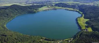
Lake Laach Magma research has brought new insights into underground volcanic systems in Europe. Scientists recently mapped the magma reservoir beneath Laacher See, a volcanic lake located in western Germany. This study used advanced tools to create a detailed 3D image of what lies beneath the surface.
Thank you for reading this post, don't forget to subscribe!The findings show that the region is still active beneath the ground, even though no eruption has occurred in recent times. This makes the area important for scientific monitoring and research.
Where Lake Laach is Located
Lake Laach, also known as Laacher See, lies in the Eifel volcanic region. This region is known for its volcanic history and geological activity.
The Eifel area includes several volcanic structures formed over thousands of years. Even today, scientists believe that the underground system is still receiving heat and magma from deeper layers of the Earth.
This makes it one of the most studied volcanic regions in Europe.
How Scientists Mapped the Magma
To understand what lies beneath Lake Laach, researchers used modern scientific methods like passive seismology and fibre-optic sensing.
Passive seismology records natural vibrations inside the Earth without creating artificial signals. This helps scientists study underground activity in a non-invasive way.
Fibre-optic cables were also used as sensors. These cables can detect small vibrations and provide detailed data about the structure of the Earth’s crust.
Large-Scale Research Effort
The study was part of a major project carried out by the GFZ German Research Centre for Geosciences and the University of Potsdam.
This project, known as the Eifel Large-N experiment, took place between 2022 and 2023. It involved setting up hundreds of seismic stations and using long fibre-optic cables to collect data.
It became one of the largest geological experiments of its kind in Central Europe, showing the importance of the research.
What the 3D Mapping Revealed
By analysing the data, scientists created a high-resolution 3D image of the magma reservoir beneath the lake. The structure was found to extend from about 2 km to 10 km below the surface.
The magma body is tilted and has a large volume, indicating that the system is complex and active. This discovery helps researchers understand how magma moves and builds up beneath volcanic regions.
Such detailed mapping was not possible earlier, making this a significant step in geology.
Microearthquakes and Underground Activity
During the study, scientists recorded more than 1,000 microearthquakes in the region. These are very small earthquakes that often go unnoticed by people.
Many of these events occurred at deeper levels, suggesting movement of magma or fluids underground. In some cases, clusters of small quakes were recorded in specific areas around the lake.
These patterns help scientists track changes inside the Earth and identify active zones.
Signs of Moving Fluids Beneath the Surface
Researchers also identified a channel in the lower crust where seismic activity has been recorded for several years. This channel appears to be linked to the movement of fluids and pressure changes.
Such activity can lead to low-frequency volcanic earthquakes, which are often associated with magma movement.
Understanding these signals is important for monitoring volcanic systems and predicting possible changes.
Why This Study Matters Today
The Lake Laach Magma study is important because it shows that some volcanic regions thought to be quiet may still be active beneath the surface.
With climate change and environmental shifts becoming global concerns, understanding Earth’s internal systems is more important than ever.
This research also highlights the role of technology in improving our knowledge of natural processes.
Advances in Geological Technology
The use of fibre-optic sensing and large-scale seismic networks shows how technology is changing the field of geology.
These tools allow scientists to collect more accurate data and create detailed models of underground structures.
As technology improves, similar studies can be conducted in other parts of the world, helping us better understand volcanic risks.
Growing Focus on Earth Monitoring
Around the world, scientists are increasing efforts to monitor natural systems like volcanoes, earthquakes, and climate patterns.
Projects like the Lake Laach study are part of this larger effort to improve safety and preparedness.
Continuous monitoring helps detect early signs of activity and supports better planning for future risks.