




Lakkundi LiDAR Survey

Lakkundi LiDAR Survey has begun in Lakkundi, Karnataka, to identify hidden and buried monuments linked to the historic Kalyana-Chalukya period. The six-month project is being carried out through an agreement between the Department of Archaeology, Museums and Heritage, Karnataka, and the National Institute of Advanced Studies (NIAS), Bengaluru. The survey will use modern geospatial technology to study the archaeological landscape without causing damage to the ground or existing structures.
The project is important because Lakkundi has a rich collection of temples, stepwells, inscriptions and other historical remains. Some structures may still be hidden below the surface. Instead of depending only on excavation, authorities are using advanced digital methods to locate these features and decide where detailed archaeological work may be required.

LiDAR Technology for Archaeological Mapping
LiDAR stands for Light Detection and Ranging. It is a remote-sensing technology that uses laser pulses to measure distances between a sensor and the ground or other surfaces. The collected information can be used to create highly detailed three-dimensional models of the landscape.
In archaeology, LiDAR can help researchers identify unusual changes in the land surface that may indicate buried walls, old foundations, roads, structures or other human-made features. Since the technology can cover large areas quickly, it is useful for studying historical sites where traditional excavation could take considerable time.
The Lakkundi project will also use Geographic Information System (GIS) mapping, remote sensing and Ground Penetrating Radar (GPR). These methods can provide information about both the visible landscape and possible underground features.
Lakkundi and the Kalyana-Chalukya Heritage
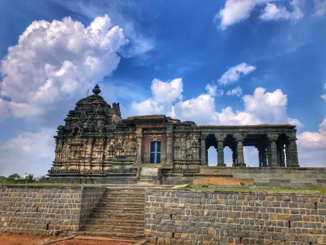
Lakkundi is located in Gadag district of Karnataka and is particularly known for its connection with the Western Chalukyas, also called the Kalyana Chalukyas. Their rule and cultural influence are generally associated with the 10th to 12th centuries CE.
The area contains examples of medieval temple architecture, decorated pillars, inscriptions and stepwells. The temples of Lakkundi show the artistic and architectural development of the period and provide information about the religious and social life of medieval Karnataka.
Lakkundi is also connected with a popular local tradition of “101 wells and 101 temples.” The new scientific survey could help researchers understand how much of this traditional description can be supported by archaeological evidence.
Survey Will Look Beneath the Surface
A major feature of the Lakkundi LiDAR Survey is its non-invasive approach. Traditional archaeological excavation involves removing layers of soil to expose buried structures. While excavation remains important, it can also disturb the archaeological context if not carefully planned.
Digital mapping allows researchers to first identify areas that may contain archaeological remains. LiDAR can reveal changes in terrain, while GPR can help detect objects and structures below the surface.
The combined use of these technologies is expected to provide a detailed archaeological map of Lakkundi. Researchers can then use the information to plan future excavation, conservation and documentation work.
Dozens of Monuments Already Identified
The archaeological importance of Lakkundi has become clearer through recent surveys and fieldwork. Since 2023, authorities have identified 70 monuments in the area.
These include 32 temples and 28 wells, along with several other historical structures. The discoveries show that the archaeological landscape of Lakkundi extends beyond the most famous monuments that are already known to visitors and researchers.
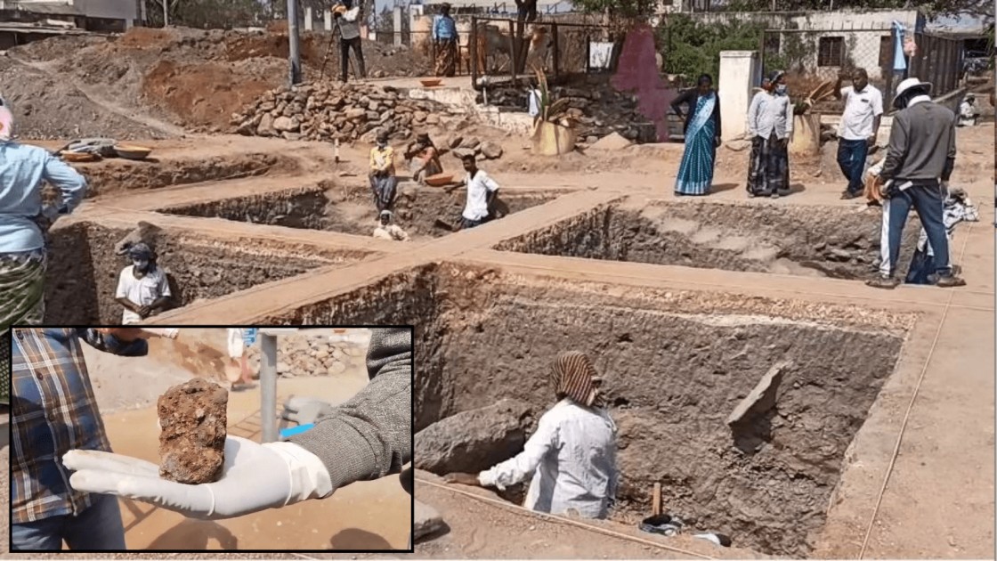
Recent excavation work has also produced a large number of artefacts. More than 1,500 artefacts were recovered during the first phase of excavation. A second phase began on 2 May 2026, and it has produced more than 1,800 artefacts.
These findings have increased interest in documenting and protecting the wider heritage landscape of the region.
Excavations Reveal an Older History
The archaeological evidence from Lakkundi is not limited to the medieval Chalukya period. Excavations at the Kote Veerabhadreshwar Temple have reportedly produced artefacts associated with the Neolithic period.
Among the discoveries were a stone axe and grey clay pots. Such findings are significant because they suggest that human activity in the Lakkundi area may have a much older history than the well-known medieval remains.
The combination of older archaeological material and later Chalukyan monuments makes Lakkundi an important location for understanding the long-term development of settlements in Karnataka.
Karnataka Plans Greater Heritage Protection
The new mapping project is also connected with wider plans to protect Lakkundi’s heritage. The Karnataka government has planned to bring 44 heritage sites in the area under state protection.
Heritage protection is important because historical structures can be affected by natural weathering, development activities, encroachment and other forms of damage. Proper mapping can help authorities identify important areas and establish clear boundaries for conservation.
The state has also proposed a three-acre open-air museum for Lakkundi. The proposed museum is expected to help document and display thousands of archaeological artefacts recovered from the area.
Technology and Heritage Conservation
The Lakkundi project reflects a wider trend in which modern technology is being combined with archaeology and heritage conservation. Digital tools can help researchers study historical landscapes while reducing the need for unnecessary excavation.
Three-dimensional terrain models, satellite information, GIS databases and ground-based scanning can create a detailed digital record of heritage sites. Such records can also be useful for monitoring changes over time and planning conservation work.
For places with large archaeological areas, technology can make it easier to identify potential structures before physical intervention begins.
A New Picture of Lakkundi’s Archaeological Landscape
The Lakkundi LiDAR Survey is expected to provide a more complete picture of the area’s archaeological remains. The project will focus not only on famous temples but also on structures that may be hidden beneath soil or difficult to identify from the surface.
The six-month survey could therefore help connect scattered archaeological discoveries and create a broader map of the historic settlement.
With recent excavations already producing thousands of artefacts and plans for additional heritage protection, the use of LiDAR, GIS and Ground Penetrating Radar adds a modern scientific layer to the study of Lakkundi’s past.