


Drainage Patterns and Drainage Systems of India: Complete Guide

Drainage Patterns and Drainage Systems of India are very important topics in geography. They help us understand how rivers flow, how landforms are shaped, and how water resources are distributed across the country. In simple words, drainage refers to the movement of water through rivers, streams, and other channels on the Earth’s surface.
Thank you for reading this post, don't forget to subscribe!A proper understanding of drainage systems is useful not only for students but also for planning agriculture, managing water resources, and preventing floods.
What is Drainage?
Drainage means the flow of water through well-defined channels such as rivers and streams. When rainwater or melted snow flows over the land, it forms channels. These channels together create a network, which is called a drainage system.
A drainage system includes:
- Main river
- Tributaries (smaller rivers joining the main river)
- River basin (area covered by a river and its tributaries)
What is a Drainage Pattern?
A drainage pattern refers to the arrangement or layout of rivers and streams in a particular area. It shows how water flows over the land surface.
The drainage pattern of a region depends on several factors:
- Slope of the land
- Type of rocks
- Geological structure
- Amount of rainfall
- Speed of water flow
Types of Drainage Patterns in India
India shows a variety of drainage patterns due to its diverse geography. Let us understand them one by one in simple language.
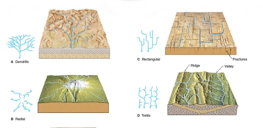
1. Dendritic Drainage Pattern
This is the most common type of drainage pattern. It looks like the branches of a tree.
Features:
- Streams join the main river like tree branches
- Tributaries join at sharp angles (less than 90°)
- Forms on uniform rock structure
Examples:
- Rivers of Northern Plains such as Indus, Ganga, and Brahmaputra
This pattern develops where the land slope is gentle and rocks are easily eroded.
2. Parallel Drainage Pattern
In this pattern, rivers flow parallel to each other.
Features:
- Rivers run in the same direction
- Found in areas with steep slopes
- Channels are long and straight
Examples:
- Rivers from Western Ghats like Godavari, Krishna, and Kaveri
This pattern forms where there is a strong slope in one direction.
3. Trellis Drainage Pattern
This pattern looks like a garden trellis or fence.
Features:
- Main rivers flow in valleys
- Tributaries join at right angles
- Found in folded mountains
Examples:
- Upper Himalayan rivers like Indus, Ganga, and Brahmaputra
This pattern develops where hard and soft rocks lie parallel.
4. Rectangular Drainage Pattern
This pattern forms where the land has cracks or faults.
Features:
- Rivers take sharp turns
- Tributaries join at right angles
- Found in fractured rock regions
Examples:
- Rivers in Vindhya Range such as Chambal, Betwa, and Ken
5. Radial Drainage Pattern
In this pattern, rivers flow outward from a central high point.
Features:
- Rivers flow in all directions from a hill or mountain
- Common around volcanoes or domes
Examples:
- Rivers from Amarkantak plateau like Narmada and Son
6. Centripetal Drainage Pattern
This is the opposite of radial pattern.
Features:
- Rivers flow towards a central low area
- Water collects in lakes or basins
Examples:
- Loktak Lake in Manipur
Sometimes these lakes dry up and form salt plains.
Folding and Faulting
The formation of drainage patterns is closely related to geological processes like folding and faulting.
Folding
- Happens when Earth’s crust bends due to pressure
- Forms mountains
- Upward fold is called anticline
- Downward fold is called syncline
Faulting
- Occurs when Earth’s crust breaks
- Leads to earthquakes
- Forms cracks and valleys
These processes affect the direction and flow of rivers.
Drainage Systems of India
The Drainage Patterns and Drainage Systems of India are divided into two main types:
- Himalayan Drainage System
- Peninsular Drainage System
Himalayan Drainage System
Overview
The rivers of the Himalayan drainage system are very important in India. These rivers are:
- Perennial (flow throughout the year)
- Fed by both melting snow and rainfall
- Form V-shaped valleys, rapids, and waterfalls in mountain regions
- Create depositional features like flat valleys, flood plains, ox-bow lakes, braided channels, and large deltas when they enter the plains
These rivers are young, active, and powerful, and they play a major role in shaping the northern plains.
Indus River System
The Indus river system is one of the largest river basins in the world. It is also known as Sindhu and is the westernmost Himalayan river in India.
Origin:
- It originates from a glacier near Bokhar Chu in the Tibetan region in the Kailash mountain range
- In Tibet, it is called “Singi Khamban” meaning “Lion’s Mouth”
Flow:
- The Indus flows through the Leh district of Ladakh in India
Major Tributaries:
- Sutlej
- Ravi
- Jhelum
- Chenab (largest tributary)
- Beas
This river system is very important for irrigation and agriculture, especially in northern India and Pakistan.
Ganga River System
The Ganga is the most important and sacred river of India.
Origin:
- It rises from the Gangotri glacier near Gaumukh (about 3,900 meters high) in Uttarakhand
- At its origin, it is called Bhagirathi
Formation:
- At Devprayag, Bhagirathi meets Alaknanda and is then called the Ganga
Flow:
- It enters the northern plains at Haridwar
- Flows through Uttarakhand, Uttar Pradesh, Bihar, and West Bengal
Major Tributaries:
- Right bank: Son
- Left bank: Ramganga, Gomati, Ghaghara, Gandak, Kosi, Mahananda
- Yamuna is the longest tributary and joins from the west
Mouth:
- It drains into the Bay of Bengal near Sagar Island
The Ganga basin is one of the most fertile regions in India and supports millions of people.
Brahmaputra River System
The Brahmaputra is one of the largest rivers in the world.
Origin:
- It originates from the Chemayungdung glacier near Mansarovar Lake in the Kailash range
Other Names:
- Called Tsangpo in Tibet (meaning “the purifier”)
- Known as Siang or Dihang when it enters India
Flow:
- Enters India west of Sadiya town in Arunachal Pradesh
Major Tributaries:
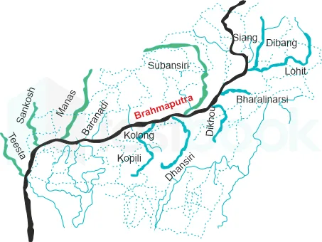
- Left bank: Dibang (Sikang), Lohit, Burhi Dihing, Dhansari
- Right bank: Subansiri, Kameng, Manas, Sankosh
Final Flow:
- It merges with the Ganga (Padma) in Bangladesh and flows into the Bay of Bengal
This river is known for its large volume of water and frequent floods in Assam.
Peninsular Drainage System
Overview
The Peninsular drainage system is older than the Himalayan system.
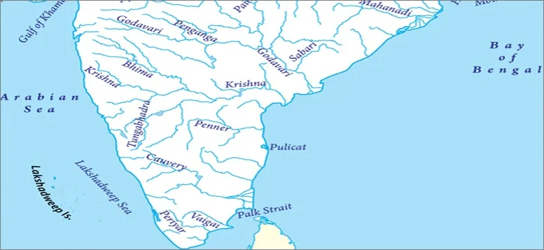
Main Features:
- Rivers have fixed courses
- They have fewer bends (absence of meanders)
- Mostly non-perennial (depend on rainfall)
- The Western Ghats act as a water divide
- Most rivers flow from west to east into the Bay of Bengal
- Exceptions: Narmada and Tapi flow westward
The main rivers include Mahanadi, Godavari, Krishna, and Kaveri.
Narmada River
- It is the largest west-flowing river of Peninsular India
- Flows through a rift valley between the Vindhya (north) and Satpura (south) ranges
Origin:
- Maikala range near Amarkantak in Madhya Pradesh
Tributaries:
- Hiran
- Orsang
- Barna
- Kolar
Basin:
- Covers Madhya Pradesh, Maharashtra, and Gujarat
Important Project:
- Sardar Sarovar Project is built on this river
Tapi River
- Another west-flowing river
- Originates from Betul district of Madhya Pradesh in the Satpura ranges
- Flows parallel to the Narmada but is shorter
Basin Covers:
- Madhya Pradesh, Maharashtra, and Gujarat
Mahanadi River
- Originates in Raipur district of Chhattisgarh
- Flows through Odisha and drains into the Bay of Bengal
Basin Distribution:
- 53% in Madhya Pradesh and Chhattisgarh
- 47% in Odisha
Tributaries:
- Seonath
- Hasdeo
- Mand
- Ib
- Jonking
- Tel
Boundaries:
- Surrounded by Central India hills (north), Eastern Ghats (south and east), and Maikala range (west)
Godavari River
- The largest river of Peninsular India
- Known as the “Dakshin Ganga”
Origin:
- Nasik district of Maharashtra
Flow:
- Passes through Maharashtra, Madhya Pradesh, Chhattisgarh, Odisha, and Andhra Pradesh
Tributaries:
- Penganga
- Indravati
- Pranhita
- Manjra
Krishna River
- Second largest east-flowing river in Peninsular India
Origin:
- Near Mahabaleshwar in the Sahyadri hills
Tributaries:
- Koyna
- Tungabhadra
- Bhima
Flow:
- Passes through Maharashtra, Karnataka, Telangana, and Andhra Pradesh before entering the Bay of Bengal
Kaveri River
- A sacred river of South India
Origin:
- Brahmagiri hills in Kodagu district of Karnataka
Tributaries:
- Arkavathi
- Hemavathi
- Bhavani
- Kabini
- Amravati
Flow:
- Flows through Karnataka, Kerala, and Tamil Nadu
- Drains into the Bay of Bengal near Puducherry
Difference Between Himalayan and Peninsular Rivers
| Feature | Himalayan Rivers | Peninsular Rivers |
|---|---|---|
| Nature | Perennial | Seasonal |
| Source | Glaciers + Rain | Rainfall |
| Age | Young | Old |
| Flow | Meandering | Straight |
| Valleys | Deep | Shallow |
Importance of Drainage Systems of India
Drainage systems are very important for:
- Agriculture (irrigation)
- Drinking water supply
- Hydroelectric power
- Transportation
- Soil fertility
They also support biodiversity and human settlements.
Conclusion
Drainage Patterns and Drainage Systems of India show how rivers shape the land and support life. From the mighty Himalayan rivers to the stable Peninsular rivers, each system has its own importance. Understanding these systems helps us use water resources wisely and protect our environment.
FAQs on Drainage Patterns and Drainage Systems of India
1. What is drainage in geography?
Drainage means the flow of water through rivers, streams, and channels on the Earth’s surface. It forms a network called a drainage system.
2. What is a drainage pattern?
A drainage pattern is the arrangement or layout of rivers and streams in a region. It shows how water flows across the land.
3. What factors affect drainage patterns?
Drainage patterns depend on:
- Slope of land
- Type of rocks
- Geological structure
- Rainfall
- Speed of water flow
4. Which is the most common drainage pattern in India?
The dendritic drainage pattern is the most common in India. It looks like tree branches and forms in areas with uniform rock structure.
5. What is the difference between radial and centripetal drainage patterns?
- Radial: Rivers flow outward from a central high point.
- Centripetal: Rivers flow inward towards a central low area or basin.
6. What are the two main drainage systems of India?
The two main drainage systems are:
- Himalayan Drainage System
- Peninsular Drainage System
7. Why are Himalayan rivers called perennial rivers?
Himalayan rivers are called perennial because they flow throughout the year. They are fed by both glacier melt and rainfall.
8. Why are Peninsular rivers mostly seasonal?
Peninsular rivers depend mainly on rainfall. During dry seasons, their water level decreases, so they are mostly seasonal.