


Jet Streams: Meaning, Formation, Types, Characteristics and Role in Indian Monsoon

Jet Streams are fast-flowing, narrow air currents found in the upper layers of the atmosphere. These winds move at very high speeds and play a major role in controlling weather and climate patterns across the world. They are located in the upper part of the troposphere, usually at an altitude between 20,000 to 50,000 feet above the Earth’s surface.
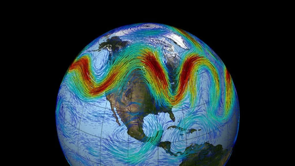
Thank you for reading this post, don't forget to subscribe!These winds generally flow from west to east, and they are called geostrophic winds because they are balanced by pressure gradient force and the Coriolis force. Jet streams are not continuous straight lines; instead, they flow in a wavy pattern across the globe.
They are extremely important in geography, especially when studying weather systems, cyclones, monsoons, and climate change.
What are Jet Streams?
Jet streams are strong air currents formed due to differences in temperature and pressure between different regions of the Earth. When warm air meets cold air, a strong pressure gradient is created, which leads to the formation of high-speed winds.
Key Features:
- Found in the upper troposphere
- Blow from west to east
- Speed ranges from 100 to 400 km/h
- Narrow but very long air currents
- Follow a wavy path called Rossby waves
The strength of jet streams depends on the temperature difference between air masses. The greater the difference, the faster the wind speed.
Formation (Genesis) of Jet Streams
Jet streams are formed due to three main types of gradients:
1. Thermal Gradient
This is the difference in temperature between the equator and the poles. The equator is hot, while the poles are cold. This temperature difference creates pressure differences in the atmosphere.
2. Pressure Gradient (Horizontal)
Due to temperature differences, pressure also varies between the equator and the poles. Air moves from high-pressure areas to low-pressure areas, creating strong winds.
3. Vertical Pressure Gradient
Over polar regions, differences between surface air and upper air pressure also contribute to jet stream formation.
Where Do Jet Streams Begin?
Jet streams begin in the tropical regions near the equator. The process can be explained in simple steps:
- The sun heats the Earth near the equator.
- Warm air rises upward.
- This rising air reaches the tropopause (boundary between troposphere and stratosphere).
- It then moves toward the colder polar regions.
- Due to Earth’s rotation, the air gets deflected and forms jet streams.
This movement creates powerful winds that circle the globe.
Types of Jet Streams
There are different types of jet streams based on their location and behavior.
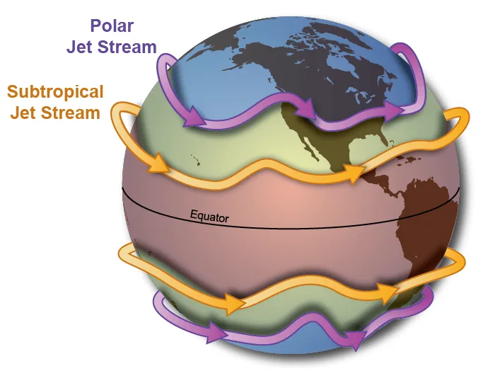
1. Subtropical Jet Stream (STJ)
- Found between 20° to 30° latitude
- Strongest during winter and early spring
- Speed can reach up to 300 knots
- Associated with clear weather conditions
- Sometimes merges with polar jet streams
This jet stream plays an important role in controlling weather in regions like India.
2. Tropical Easterly Jet Stream (TEJ)
- Occurs during the summer season
- Found over India, Southeast Asia, and Africa
- Blows from east to west
- Develops due to heating of the Tibetan Plateau
This jet stream is very important for the Indian monsoon system.
3. Polar Night Jet Stream
- Found in the upper stratosphere over polar regions
- Strong during winter
- Associated with very cold conditions
- Occurs above sub-polar low-pressure belts
Characteristics of Jet Streams
Jet streams have several unique features:
1. High Speed
They are among the fastest winds in the atmosphere.
2. Meandering Path (Rossby Waves)
Jet streams do not flow straight. They move in a wavy pattern called Rossby Waves, which influence weather systems.
3. Seasonal Variation
- Stronger in winter
- Weaker in summer
4. Linked with Atmospheric Cells
Their formation is connected with:
- Hadley Cell
- Ferrel Cell
5. Vertical Movement
Air within jet streams undergoes:
- Expansion (low pressure)
- Compression (high pressure)
Climatic Importance of Jet Streams
Jet streams have a major impact on global weather and climate.
1. Formation of Clouds
Jet streams sometimes carry moisture into higher layers of the atmosphere, forming noctilucent clouds.
2. Cyclones and Anticyclones
They influence the formation of:
- Cyclones (low pressure)
- Anticyclones (high pressure)
3. Ozone Layer Impact
Jet streams can carry substances that may contribute to ozone depletion.
4. Weather Patterns
They control:
- Rainfall
- Temperature changes
- Storm movements
Jet Streams and Indian Monsoon
Jet streams play a crucial role in the monsoon system of India. Their position, strength, and seasonal movement directly control the onset, intensity, and withdrawal of monsoon winds.
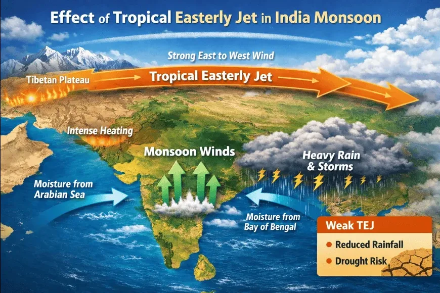
Indian Monsoon Mechanism and Role of Subtropical Jet Stream (STJ)
- The burst of the Indian monsoon mainly depends on upper air circulation, which is dominated by the Subtropical Jet Stream (STJ). When this circulation changes, the monsoon begins suddenly.
- The Southwest Monsoon is linked with the Tropical Easterly Jet Stream. It flows between 8°N to 35°N latitudes and brings heavy rainfall to most parts of India.
- The Northeast Monsoon (winter monsoon) is associated with the Subtropical Westerly Jet Stream. It flows between 20° to 35° latitudes and mainly brings rainfall to Tamil Nadu.
Seasonal Migration of Subtropical Jet Stream (STJ)
- In winter, the STJ flows along the southern slopes of the Himalayas. In summer, it shifts northward towards the Tibetan Plateau, showing a major seasonal change.
- The movement of the jet stream indicates the onset and withdrawal of the monsoon. When it shifts north, the monsoon begins, and when it returns south, the monsoon withdraws.
- The northward shift of the subtropical jet is the first clear signal of the arrival of the monsoon over India.
STJ in Summer Season
- With the beginning of summer, the STJ starts moving northward. This shift allows warm conditions to develop over northern India, making the weather hot, dry, and dusty.
- As the STJ weakens south of Tibet, the ITCZ (Inter Tropical Convergence Zone) moves northward. However, the monsoon does not begin until the upper air circulation fully changes.
- By the end of May, the subtropical jet breaks and shifts north of the Tibetan Plateau. This change creates a sudden burst of monsoon due to pressure changes.
- The Tibetan Plateau becomes very hot in summer, causing air to rise rapidly. This rising air splits into two streams near the tropopause—one moving as an easterly jet and the other as a westerly jet.
- The eastern jet becomes stronger and is located around 15°N latitude, while the western jet moves towards the north of the Himalayas.
- Strong easterly winds in the upper atmosphere combine with westerly winds in the lower atmosphere. This strengthens the southwest monsoon and leads to heavy rainfall.
- The intense heating of the Tibetan Plateau and Central Asia is a major reason behind the formation of these powerful monsoon winds.
- The westerly jet also creates a high-pressure area over the Arabian Sea. At the same time, low pressure develops over the Indian landmass.
- Winds from the high-pressure Arabian Sea move towards the low-pressure area over India. This movement forms the southwest monsoon winds, bringing rainfall.
STJ in Winter Season
- During winter, the subtropical westerly jet stream blows from west to east across West and Central Asia, influencing India’s winter weather.
- The Himalayan ranges divide this jet into two branches. One branch flows north of the Tibetan Plateau, while the other flows south of the Himalayas.
- The southern branch flows along approximately 25°N latitude and directly affects the Indian subcontinent.
- These westerly winds bring western disturbances, which cause winter rainfall in North India and snowfall in the Himalayas.
Southwest Monsoon
- Linked with the Tropical Easterly Jet Stream
- Occurs between 8°N to 35°N latitude
- Brings heavy rainfall to India
Northeast Monsoon
- Associated with Subtropical Westerly Jet Stream
- Occurs during winter
- Brings rainfall to Tamil Nadu
Seasonal Migration of Jet Streams
Jet streams shift their position according to seasons, which directly affects monsoon patterns.
In Winter:
- Located south of the Himalayas
- Strong and stable
In Summer:
- Shift northwards
- Move over the Tibetan Plateau
This seasonal movement signals the arrival and withdrawal of the monsoon.
Jet Streams in Summer Season
During summer:
- The subtropical jet moves northward
- Northern India becomes hot and dry
- Hot winds like loo blow across plains
Important Changes:
- The ITCZ shifts north
- The subtropical jet weakens
- Monsoon winds start developing
Burst of Monsoon
The monsoon begins suddenly due to:
- Shift of jet stream
- Formation of low pressure over India
- Movement of high pressure from Arabian Sea
This results in heavy rainfall across India.
Role of Tibetan Plateau
- Gets extremely hot in summer
- Causes air to rise rapidly
- Divides into two streams:
- Easterly jet (towards equator)
- Westerly jet (towards poles)
This division strengthens the monsoon system.
Jet Streams in Winter Season
During winter:
- The subtropical jet stream splits into two branches:
- Northern branch (north of Himalayas)
- Southern branch (south of Himalayas)
Western Disturbances
- Weather systems brought by jet streams
- Cause:
- Rainfall in North India
- Snowfall in Himalayas
Jet Streams and Northeast Monsoon
Jet streams also help in forming the Northeast Monsoon.
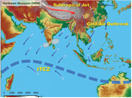
Process:
- Cold Westerly Jet Stream and High Pressure Formation
The westerly jet stream acts as a cold wind that pushes air downward toward the surface. This creates a high-pressure area over north-western parts of India during winter. - Movement of Dry Winds Toward Bay of Bengal
Dry winds from this high-pressure region begin to move toward the low-pressure area over the Bay of Bengal. This movement is essential in setting up the winter wind system. - Cold Wave Conditions in Northern India
As these winds flow across northern India, they bring cold wave conditions. States like Uttar Pradesh and Bihar experience a sharp drop in temperature during this period. - Transformation into Northeast Monsoon Winds
After reaching the Bay of Bengal, these winds come under the influence of the Ferrel Cell. They change direction and transform into the northeast monsoon winds. - Rainfall over Tamil Nadu Coast
These winds pick up moisture from the Bay of Bengal and move toward the Tamil Nadu coast. As a result, this region receives significant rainfall during the winter season.
Impact on Indian Weather
Jet streams influence:
- Rainfall distribution
- Heat waves
- Cold waves
- Storm formation
Examples:
- Cold waves in North India
- Heavy rainfall in coastal regions
- Sudden weather changes
Jet Streams and Climate Change
In recent years, jet streams have been affected by global warming.
Changes Observed:
- Slower movement
- Increased waviness
- Extreme weather events
Effects:
- Heatwaves
- Floods
- Unpredictable rainfall
Importance in Aviation
Jet streams are useful for aircraft:
- Planes flying with jet streams save fuel and time
- Planes flying against jet streams take longer
Conclusion
Jet streams are powerful atmospheric winds that play a major role in shaping global weather and climate. From influencing rainfall patterns to controlling monsoon systems, their importance cannot be ignored.
In India, jet streams are directly linked to the onset and withdrawal of monsoon, making them essential for agriculture and the economy. Understanding jet streams helps us predict weather patterns, manage disasters, and study climate change.
FAQs on Jet Streams
1. What are Jet Streams?
Jet streams are fast-moving air currents found in the upper atmosphere.
2. At what height do Jet Streams occur?
They occur between 20,000 to 50,000 feet above Earth.
3. Why are Jet Streams important?
They control weather patterns, monsoons, and climate systems.
4. What is the speed of Jet Streams?
They can reach speeds of 100 to 400 km/h.
5. What is the role of Jet Streams in monsoon?
They help in the onset, intensity, and withdrawal of monsoon winds.