


Climatic Regions of World: Major Types and Their Characteristics(Part-I)

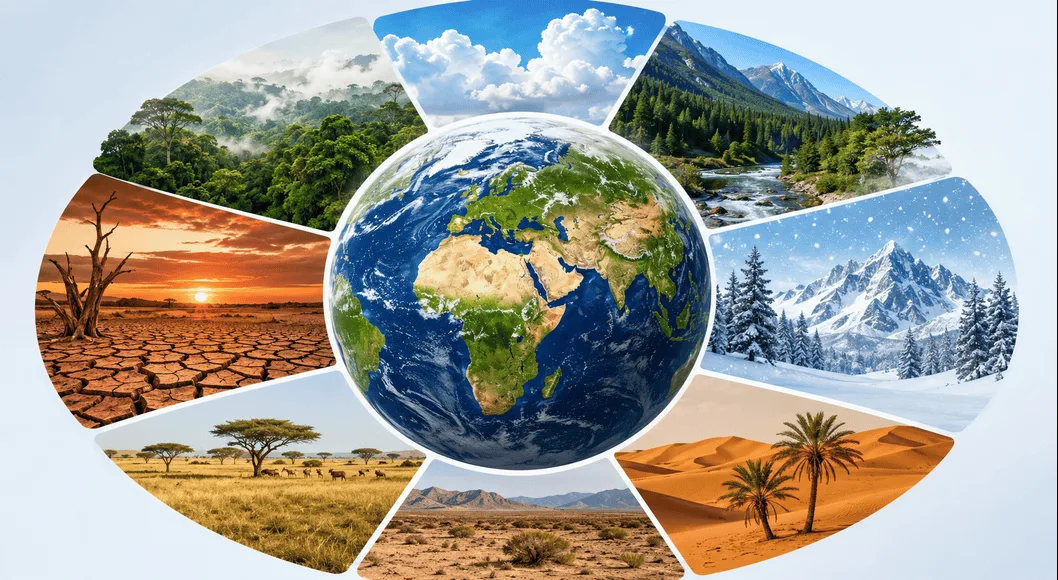
Climatic Regions of the World is an important topic in geography that helps us understand how different parts of the Earth experience different weather conditions over a long period of time. Climate affects human life, vegetation, animals, agriculture, and even economic development.
Thank you for reading this post, don't forget to subscribe!What is Climate?
Climate means the average weather conditions of a place over a long period of time, usually 30 years or more. It includes temperature, rainfall, humidity, and wind patterns.
For example:
- Places near the equator are generally hot.
- Places near the poles are very cold.
This happens because the Sun’s rays fall directly on the equator, making it hot, while the poles receive slanting rays, making them cold.
Difference Between Weather and Climate
Many people confuse weather and climate, but they are not the same.
- Weather refers to short-term atmospheric conditions. It can change every hour or day.
- Climate refers to the average weather over a long period.
For example:
- Rain today is weather.
- Rainfall pattern over 30 years is climate.
Factors Affecting Climate
Several factors influence the climate of a place:
- Latitude – Distance from the equator affects temperature.
- Altitude – Higher places are cooler.
- Distance from Sea – Coastal areas have moderate climate.
- Ocean Currents – Warm or cold currents affect temperature.
- Relief (Topography) – Mountains can block winds.
- Vegetation – Forests affect humidity and rainfall.
- Winds – Carry heat and moisture.
Classification of World Climate
Scientists have classified climates into different types to make them easier to understand and study. These classifications are based on temperature, rainfall, and vegetation. Two of the most important systems are the Koppen Climate Classification and the Thornthwaite Classification.
1. Koppen Climate Classification
The Koppen Climate Classification is the most widely used system in the world. It was developed by the scientist Wladimir Koppen.
Main Idea of Koppen Classification
Koppen found a strong connection between climate and natural vegetation. He believed that similar climates support similar types of plants. So, he used temperature and rainfall data to classify climates.
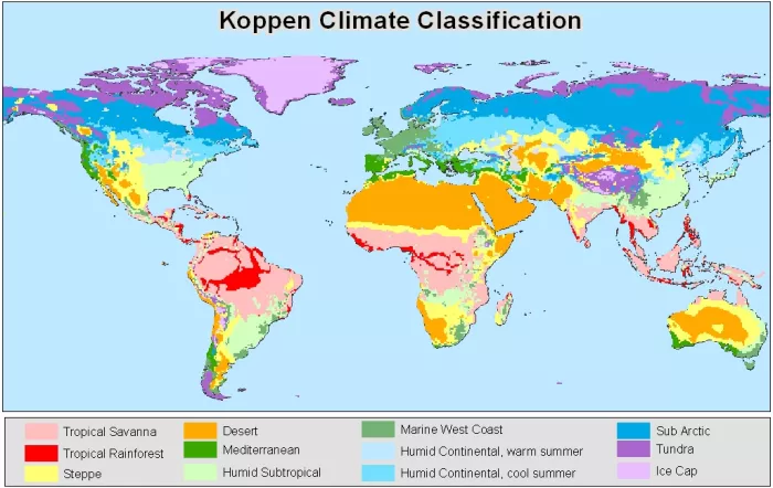
This system is called an empirical classification because it is based on real data like:
- Mean annual temperature
- Mean monthly temperature
- Average rainfall
Major Climate Groups
Koppen divided the world into five main climate groups:
- A – Tropical Climate (Hot and Wet)
- B – Dry Climate (Desert and Semi-desert)
- C – Mild Temperate Climate
- D – Cold Temperate Climate
- E – Polar Climate
Among these:
- A, C, D, and E represent humid climates
- B represents dry climates
Use of Letters in Koppen System
Koppen used a combination of capital and small letters to describe climates in detail.
Capital Letters
- Show the main climate type (A, B, C, D, E)
Small Letters
- Show the season of dryness
Meanings of small letters:
- f – No dry season (rain all year)
- m – Monsoon climate
- w – Dry winter
- s – Dry summer
Role of Latitude
The Koppen classification is also influenced by latitude, which means the distance of a place from the equator. Latitude affects how much sunlight a place receives, and this directly affects climate.
Why Koppen Classification is Important
- It is simple and easy to use
- It connects climate with vegetation
- It helps in understanding global climate patterns
2. Thornthwaite Classification
The Thornthwaite Classification was developed by Charles Warren Thornthwaite in 1931. This system is more scientific and focuses on water availability and plant needs.
Main Idea of Thornthwaite Classification
This system is based on the concept of precipitation effectiveness (P/E):
- P (Precipitation) = Total rainfall
- E (Evaporation) = Water lost through evaporation
The ratio of P to E helps to understand how much water is available for plants.
P/E Index
- The sum of monthly P/E values gives the P/E Index
- This index is used to divide the world into different humidity regions
Improvement in 1948
In 1948, Thornthwaite improved his system by adding the Moisture Index, which considers:
- Potential Evapotranspiration (PE)
(Water needed by plants based on temperature and day length)
In dry areas:
- Moisture index becomes negative
- Because rainfall is less than water demand
Humidity Regions (Based on P/E Index)
Thornthwaite divided climates into five main regions:
- A (P/E > 128) – Wet Climate (Rainforest)
- B (64–127) – Humid Climate (Forest)
- C (32–63) – Sub-humid Climate (Grassland)
- D (16–32) – Semi-arid Climate (Steppe)
- E (< 16) – Arid Climate (Desert)
Seasonal Rainfall Subdivisions
Each region is further divided based on rainfall distribution:
- Y – Heavy rainfall in all seasons
- s – Low rainfall in summer
- w – Low rainfall in winter
- d – Low rainfall in all seasons
Importance of Thornthwaite Classification
- Helps in understanding drought and moisture conditions
- Focuses on water availability
- Useful for agriculture and irrigation planning
Major Climatic Regions of the World
Now let us study the important climatic regions of the world in detail. Each region has its own temperature, rainfall, vegetation, and human activities.
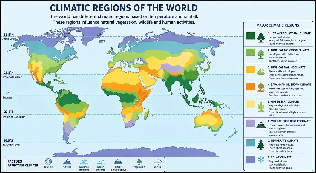
1. Hot Wet Equatorial Climate
Location
The Hot Wet Equatorial Climate is found between 5° North and 10° South of the equator.
It is mainly seen in:
- Amazon Basin (South America)
- Congo Basin (Africa)
- Malaysia and East Indies
These regions are mostly lowland areas near the equator.
Temperature
- Temperature remains high and uniform throughout the year.
- Average temperature is around 24°C to 27°C.
- There is very little seasonal change.
- There is no winter season.
Rainfall
- Rainfall is heavy and well distributed throughout the year.
- Annual rainfall is usually above 150 cm, and in some places it reaches 250–300 cm.
- There is no dry month.
- Monthly rainfall is usually above 6 cm.
- Due to strong heat, convectional rainfall occurs almost daily, often with afternoon thunderstorms.
Natural Vegetation
- Dense tropical rainforests grow here.
- Forests are very thick and are called “selvas” in the Amazon region.
- Trees are evergreen and grow very tall.
- Important trees include:
- Mahogany
- Ebony
- Dyewoods
- In coastal areas, mangrove forests are also found.
People and Economy
Major Tribes
- Tribes of Amazon Basin
- Pygmies of Congo Basin
- Orang Asli of Malaysia
Economic Activities
- Many people live as hunters and gatherers.
- Some practice shifting cultivation.
- Plantation farming is also done, including:
- Rubber
- Cocoa
2. Tropical Monsoon Climate
Location
- Found between 5° and 30° latitudes on both sides of the equator.
- Common in:
Temperature
- Climate is hot throughout the year.
- There is a clear difference between summer and winter.
- Summer temperatures range from 27°C to 32°C.
Rainfall
- Rainfall is seasonal and mostly comes from monsoon winds.
- Average annual rainfall is around 150 cm.
- Rainfall is caused by:
- Cyclonic rainfall
- Orographic rainfall
- Most rain comes from moist South-West monsoon winds.
Natural Vegetation
- Forests are mostly deciduous (trees shed leaves in dry season).
- Forests are less dense than equatorial forests.
- Important trees:
- Teak
- Sal
- Acacia
- Eucalyptus
Economy
- People mainly depend on agriculture.
- Major crops include:
- Rice
- Wheat
- Pulses
- Cotton
- Jute
- Sugarcane
- Tea and Coffee
- Animal rearing is also common.
- This region is highly developed in agriculture and mineral resources.
3. Tropical Marine Climate
Location
- Found in coastal areas such as:
- Central America
- West Indies
- Philippines
- East Africa
- Madagascar
- Eastern Brazil
Temperature
- Temperature is warm and moderate throughout the year.
Rainfall
- Rainfall is high due to the influence of the sea.
Vegetation
- Dense forests are found, but they are less thick than equatorial forests.
Economy
- Main activities include:
- Farming
- Fishing
4. Savannah or Sudan Climate
Location
- Found between equatorial forests and deserts.
- Located between 5° and 20° latitudes.
- Major regions:
- Sudan (Africa)
- East and South Africa
- Brazil (Campos)
- Venezuela (Llanos)
Temperature
- Climate is warm throughout the year.
- Average temperature: 24°C to 27°C.
- Annual temperature range is small (3°C to 8°C).
- There is a large difference between day and night temperatures.
Rainfall
- Rainfall is moderate (100–150 cm).
- There are clear wet and dry seasons.
- Rain is brought by trade winds.
Natural Vegetation
- Known for grasslands with scattered trees.
- Tall grasses like elephant grass are common.
- Trees are hard and deciduous.
- In Australia, plants like:
- Mallee
- Mulga
- Spinifex grass are found
People and Economy
- Many tribes live here:
- Masai (pastoralists)
- Hausa (farmers)
- Activities include:
- Cattle rearing
- Limited farming
5. Hot Desert Climate
Location
- Found between 15° and 30° latitudes on western sides of continents.
- Major deserts:
- Sahara Desert
- Arabian Desert
- Thar Desert
- Kalahari Desert
- Namib Desert
- Australian Desert
- In North America:
- Mojave
- Sonoran
- In South America:
- Atacama Desert (driest desert)
Temperature
- Very hot during the day.
- Average summer temperature is around 30°C.
- Very large difference between day and night temperatures (14°C to 25°C).
- Nights can be cold; frost may occur in winter.
Rainfall
- Rainfall is very low (less than 25 cm).
- Some areas like Atacama receive almost no rainfall.
- Air is dry due to high-pressure belts.
- Rain occurs rarely as short thunderstorms.
- Humidity is very low (below 30% in interiors).
Vegetation
- Vegetation is very sparse.
- Plants are drought-resistant (xerophytic):
- Cactus
- Thorny bushes
- Long-root grasses
- Small acacia trees
People and Economy
- Some people live as hunters and gatherers:
- Bushmen (Kalahari)
- Aborigines (Australia)
- Others are nomadic herdsmen:
- Bedouins (Arabia)
- Tuaregs (Sahara)
- Mongols (Gobi)
- Some farming is done in oasis areas:
- Wheat
- Barley
- Fruits
- Important economic activities:
- Oil production (Persian Gulf)
- Gold mining (Australia)
- Diamond mining (Kalahari)
- Copper mining (Chile)
6. Mid-Latitude Desert Climate
Location
- Found in interior regions and rain-shadow areas.
- Examples:
- Gobi Desert
- Patagonian Desert
Temperature
- Hot summers and cold winters.
Rainfall
- Very low rainfall due to rain-shadow effect.
Vegetation
- Sparse vegetation such as:
- Shrubs
- Grasses
Economy
- People follow:
- Nomadic lifestyle
- Some mining activities
Special Features of Desert Climate
- Very low humidity
- Clear skies most of the year
- High evaporation rate
- Strong and dry winds
- Frequent sandstorms
Importance of Climatic Regions
Understanding climatic regions is very important because:
- Helps in agriculture planning.
- Helps in settlement of people.
- Influences natural vegetation and wildlife.
- Important for economic activities.
- Helps in disaster management.
Conclusion
Climatic Regions of the World help us understand how temperature and rainfall vary across the Earth. From hot equatorial forests to dry deserts, each region has its own unique features. These climates affect how people live, what crops they grow, and how they develop economically. By studying these regions, we can better understand our planet and use its resources wisely.
FAQs
1. What is climate?
Climate is the average weather condition of a place over a long period of time.
2. What is the difference between weather and climate?
Weather is short-term, while climate is long-term average conditions.
3. Who developed the Koppen classification?
Wladimir Koppen developed it.
4. Which climate has the highest rainfall?
Equatorial climate has the highest rainfall.
5. What type of vegetation is found in deserts?
Drought-resistant plants like cactus and thorny bushes.