


Landforms Made by Wind, Water and Glaciers(Part-II)

Landforms made by wind, water and glaciers are some of the most important topics in physical geography. These landforms help us understand how the Earth’s surface changes over time. Natural forces like wind, sea waves, and glaciers are constantly shaping the land. These processes may be slow, but over thousands and millions of years, they create beautiful and unique features on the Earth.
Thank you for reading this post, don't forget to subscribe!What are Landforms Made by Wind?
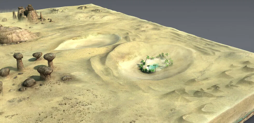
Wind is a powerful natural agent, especially in desert areas. It plays a major role in shaping land where there is little vegetation and dry, loose soil.
How Wind Erodes the Land
Wind shapes land mainly through erosion and transportation.
1. Deflation
Deflation is the process in which wind removes loose and fine particles like dust and sand from the surface. Over time, this creates hollow areas in the ground.
2. Abrasion
Abrasion happens when sand particles carried by wind hit rock surfaces and slowly wear them down. It works like sandpaper rubbing against a surface.
3. Attrition
In attrition, sand particles collide with each other in the air. Because of this collision, they become smaller and smoother.
Transportation of Materials by Wind
Wind carries particles in three main ways:
- Suspension: Very fine particles are lifted and carried over long distances.
- Saltation: Small particles bounce along the surface.
- Surface Creep: Larger particles roll or slide on the ground.
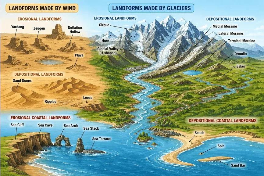
Erosional Landforms Formed by Wind
1. Deflation Hollows
These are shallow depressions formed when wind removes loose particles. Some can grow very large and are also called blowouts.
2. Caves
When deflation hollows become deeper and wider, they may form caves due to continuous wind action.
3. Yardangs
Yardangs are long ridges and grooves formed in desert areas. They are created when wind erodes soft rocks more than hard rocks.
4. Zeugen
Zeugen are flat-topped rock formations found in deserts. They are made of layers of hard and soft rocks.
5. Playas
Playas are flat, dry basins found in deserts. Sometimes, they get filled with water, but later the water evaporates, leaving salt and mud behind.
Depositional Landforms Formed by Wind
1. Ripples
Ripples are small wave-like patterns formed on sand surfaces due to wind movement.
2. Loess
Loess is made of fine dust particles deposited by wind. It is very fertile and useful for agriculture.
3. Sand Dunes
Sand dunes are heaps of sand formed by wind. They are common in deserts.
Types of Sand Dunes
- Barchans: Crescent-shaped dunes with horns pointing away from the wind.
- Seif Dunes: Long, narrow dunes formed in areas with changing wind directions.
What are Coastal Landforms?
Coastal landforms are created by the action of sea waves. These processes are very active and are considered among the most dynamic geological processes because coastlines can change even within a year or a short period of time.
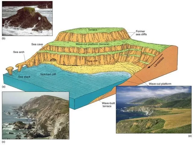
Coastal landforms are not only shaped by waves but also depend on:
- The shape and configuration of the land and sea floor
- Whether the coast is moving forward into the sea (emerging coast)
- Or whether the land is sinking and the sea is moving inward (submerging coast)
Erosional Coastal Landforms
These landforms are formed when sea waves remove material from the coast.
1. Sea Cliffs
Sea cliffs are steep and vertical rock faces formed when strong waves continuously hit a sloping land. Processes like hydraulic action (force of water), abrasion (rubbing by sand and pebbles), and chemical action slowly cut a notch at the base of the cliff. Over time, this weakens the cliff and causes it to move backward (retreat landward).
2. Sea Caves
Sea caves are formed when waves attack weak points in rocks, especially in areas where rocks have cracks or joints. These caves are commonly found in headlands where wave energy is strong due to wave refraction.
3. Sea Arches and Sea Stacks
When sea caves become larger and meet from opposite sides of a headland, they form a sea arch. If the arch collapses due to continuous erosion, a tall pillar of rock remains in the sea. This pillar is called a sea stack.
4. Sea Terraces
Sea terraces are flat rock surfaces formed when a sea cliff and its wave-cut platform are lifted above sea level. This usually happens due to changes in sea level or land uplift.
Depositional Coastal Landforms
These landforms are created when materials carried by waves are deposited along the coast.
1. Beaches
Beaches are formed by the accumulation of loose materials like sand, pebbles, and even large rocks along the shore. Beaches around the world can have different types of materials, from fine sand to large boulders.
2. Spits
A spit is a long, narrow stretch of sand or sediment that is attached to the land at one end and extends into the sea. Spits are formed by a process called longshore drift, where waves move sand along the coastline. They usually form where the coastline bends inward.
3. Bars
Bars, also called sandbars or offshore bars, are ridges of sand formed by waves away from the shore. They may be completely underwater or partly visible above the water surface.
Landforms Formed by Glaciers
Glaciers are large masses of ice that move slowly over land. They play a very important role in shaping landscapes, especially in cold regions like high mountains and polar areas. Glaciers are very powerful natural agents. They can erode rocks and soil, carry sediments from one place to another, and deposit them in different locations.
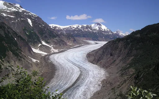
A glacier can move in two main ways. It can spread like a large sheet over land, which is called a continental glacier or piedmont glacier. It can also move like a river of ice flowing down mountain slopes into valleys. These are called mountain or valley glaciers.
Erosional Landforms Formed by Glaciers
1. Glacial Valleys (Troughs)
Glacial valleys are U-shaped valleys with wide floors and steep sides. These valleys are formed when glaciers move through existing river valleys and widen them.
The valley floor is usually smooth, and sometimes it contains debris left behind by glaciers. This debris may look like small hills or ridges called moraines. In some cases, these valleys may appear swampy due to water accumulation.
Very deep glacial valleys that get filled with seawater are called fjords. These are commonly found in high latitude regions.
2. Cirques
Cirques are bowl-shaped depressions found at the upper part or head of a glacier. They are one of the most common landforms in glaciated mountain regions.
Cirques are deep, wide, and surrounded by very steep rock walls. These walls may look almost vertical. After the glacier melts, water often collects in these depressions and forms small lakes. These lakes are called cirque lakes or tarn lakes.
3. Horns and Serrated Ridges
Horns are sharp and pointed mountain peaks. They are formed when several glaciers erode a mountain from different sides.
This happens because glaciers cut into the mountain from different directions. Over time, the sides become steeper and sharper. When three or more cirques meet, they form a high, pointed peak known as a horn.
These peaks are very steep and look like pyramids. The ridges between cirques are also sharp and jagged, which are sometimes called serrated ridges.
Depositional Landforms Formed by Glaciers
1. Glacial Till
Glacial till is the mixture of rocks, sand, and soil that is deposited directly by melting glaciers. It includes both large and small particles, and they are not sorted in any order. This means the material is rough and uneven.
When glaciers melt, some of the smaller rock particles are carried away by meltwater streams. These materials are later deposited in layers. Such deposits are called outwash deposits or glaciofluvial deposits. Unlike glacial till, these deposits are more sorted and arranged in layers because they are carried by flowing water.
2. Moraines
Moraines are long ridges formed by the deposition of glacial till. They are very important features that show the movement and size of glaciers.
There are different types of moraines:
- Terminal Moraine: These are found at the end (toe) of the glacier. They mark the farthest point reached by the glacier.
- Lateral Moraine: These are formed along the sides of a glacier, parallel to the valley walls.
- Medial Moraine: These are found in the middle of a glacier. They are formed when two glaciers join and their lateral moraines combine.
- Ground Moraine: When glaciers melt and retreat, they leave behind a flat or uneven layer of till across the valley floor.
Medial moraines are usually not as clearly formed as lateral moraines, and sometimes they are difficult to distinguish from ground moraines.
3. Eskers
Eskers are long, narrow, and winding ridges made of sand and gravel. They are formed by meltwater rivers that flow inside or beneath glaciers through tunnels.
Over time, these tunnels get filled with sediments carried by the flowing water. When the glacier melts and disappears, the sediments remain behind as raised ridges on the land. These ridges are called eskers.
4. Drumlins
Drumlins are smooth, oval-shaped hills formed mainly by glacial till along with some sand and gravel. They are formed beneath glaciers and are aligned in the direction of glacier movement.
Drumlins can be up to 1 kilometer long and about 30 meters high. One end of a drumlin, called the stoss end, faces the glacier and is steeper and rounded. The other end, called the tail, is longer and more gently sloping.
These landforms help scientists understand the direction in which glaciers moved in the past.
Importance of Studying Landforms
Understanding landforms made by wind, water and glaciers is important because:
- It helps us understand Earth’s history
- It explains natural disasters like erosion and flooding
- It helps in agriculture and land use planning
- It is useful for exams like UPSC, SSC, and school boards
Conclusion
Landforms made by wind, water and glaciers show how powerful natural forces shape our planet. Wind creates features like dunes and yardangs in deserts. Sea waves form cliffs, beaches, and sea stacks along the coast. Glaciers create valleys, moraines, and drumlins in cold regions.
All these processes may seem slow, but they continuously change the Earth’s surface. By studying them, we can better understand nature and protect our environment.
FAQs
1. What are landforms made by wind?
Landforms made by wind include dunes, loess, yardangs, and deflation hollows.
2. What are coastal landforms?
Coastal landforms are features like beaches, cliffs, and sea stacks formed by sea waves.
3. What is a glacier?
A glacier is a large mass of ice that moves slowly over land.
4. What is a moraine?
A moraine is a ridge formed by debris deposited by a glacier.
5. Why are sand dunes important?
Sand dunes help protect desert ecosystems and also show wind direction.