


Landforms of the Earth(Part-I): Complete Guide to Earth Surface Features

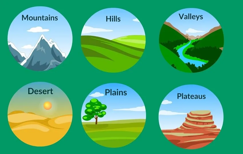
Landforms of the Earth are the natural features that we see on the surface of our planet. These include mountains, valleys, plains, rivers, plateaus, and many more. Every landform has its own shape, size, and structure. Some landforms are very large, while others are small, but all of them together make the Earth’s surface unique and diverse.
Thank you for reading this post, don't forget to subscribe!A landform is created by natural forces. These forces are called geomorphic processes. These processes include erosion, weathering, deposition, and movements inside the Earth. These processes work very slowly, sometimes taking thousands or even millions of years to form a landform.
Landforms are not permanent. They change over time. Some landforms grow, while others get destroyed or reshaped due to continuous natural processes like wind, water, ice, and underground movements.
What are Landforms?
A landform is any natural feature on the Earth’s surface. It can be big like a mountain or small like a hill. Each landform is made of different materials such as rocks, soil, sand, or minerals.
Key Features of Landforms:
- They have different shapes and sizes
- They are formed by natural processes
- They change over time
- They are found everywhere on Earth
For example:
- Mountains are formed by movements inside the Earth
- Rivers shape valleys by flowing water
- Wind creates sand dunes in deserts
Major Forces Behind Landforms of the Earth
Landforms are mainly formed by two types of forces:
1. Internal Forces (Endogenic Forces)
These forces come from inside the Earth.
Examples:
- Earthquakes
- Volcanic eruptions
- Plate movements
These forces build landforms like mountains and plateaus.
2. External Forces (Exogenic Forces)
These forces act on the Earth’s surface.
Examples:
- Running water
- Wind
- Glaciers
- Groundwater
These forces break down and reshape landforms.
Landforms Made by Running Water
Running water is one of the most powerful forces shaping the Earth’s surface. Rivers and streams slowly cut through rocks and soil, creating many types of landforms.
In areas with heavy rainfall, running water plays a very important role in shaping the land.
Erosional Landforms by Running Water
Erosion means wearing away of land. Flowing water removes soil and rocks and creates different landforms.
1.Valleys
Valleys are low areas between hills or mountains. They are formed when rivers cut into the land.
- They start as small channels
- Gradually become larger and deeper
- Over time, they turn into wide valleys
2. Gorge
A gorge is a deep and narrow valley with very steep sides.
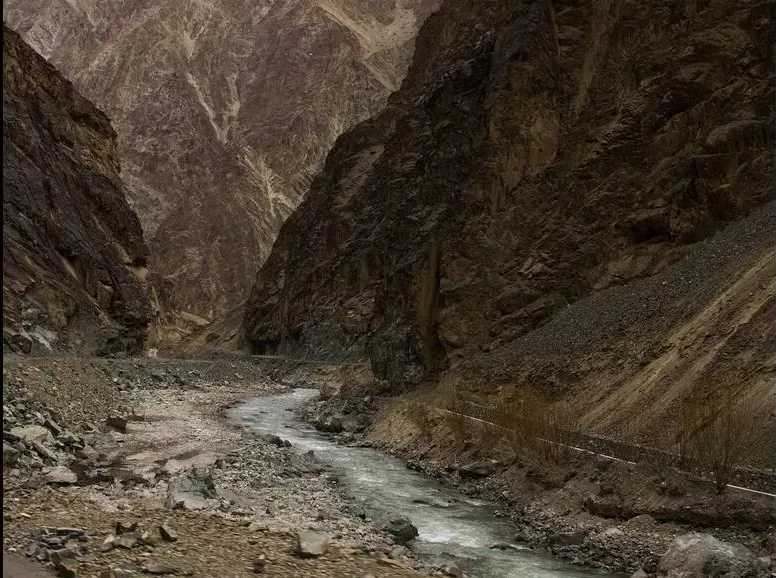
- Found mostly in hard rocks
- Width is almost the same at top and bottom
- Formed by strong river erosion
3. Canyon
A canyon is similar to a gorge but has step-like sides.
- Wider at the top than bottom
- Common in areas with layered rocks
- Example: Grand Canyon
4. Potholes and Plunge Pools
- Potholes are small circular holes in river beds
- Formed by rotating stones and pebbles
- Plunge pools are larger and deeper holes
They help rivers deepen their valleys.
5. Incised or Entrenched Meanders
These are deep curves cut into rocks.
- Formed when rivers cut downward quickly
- Found in hard rock regions
- Very deep and wide
6. River Terraces
River terraces are step-like landforms along rivers.
- Represent old river levels
- Formed by vertical erosion
- Can be paired or unpaired
Depositional Landforms by Running Water
Deposition means the laying down of materials like sand, silt, and clay.
1. Alluvial Fans
- Formed at the base of mountains
- River loses speed and drops sediments
- Shape looks like a fan
2. Deltas
Deltas form where rivers meet the sea.
- Sediments are deposited at river mouth
- Shape is triangular or fan-like
- Very fertile land
3. Floodplains
Floodplains are flat areas near rivers.
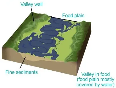
- Formed by deposition during floods
- Very fertile soil
- Includes floodway and flood fringe
4. Meanders and Oxbow Lakes
- Meanders are bends in rivers
- Formed due to slow flow and erosion
- When a bend is cut off, it forms an oxbow lake
Landforms Made by Groundwater
Groundwater also plays an important role in shaping landforms, especially in limestone regions.
Rainwater mixes with carbon dioxide and forms a weak acid called carbonic acid. This acid dissolves rocks like limestone and creates special landforms.
This type of landscape is called Karst topography.
Erosional Landforms by Groundwater
1. Swallow Holes and Sinkholes
- Circular depressions in the ground
- Formed by dissolution of limestone
- Sinkholes are larger than swallow holes
2. Lapies
- Sharp grooves and ridges on limestone surface
- Formed by chemical weathering
3. Limestone Pavements
- Flat rocky surfaces
- Look like artificial pavement
- Have cracks and blocks
4. Caves
Caves form underground in limestone areas.
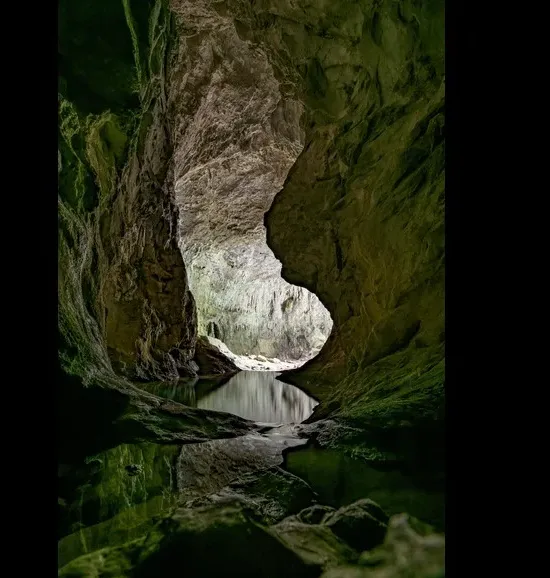
- Created by dissolution of rock
- Can be very large and deep
- Often contain beautiful formations
Depositional Landforms by Groundwater
1. Stalactites
- Hang from cave roofs
- Look like icicles
- Formed by dripping water
2. Stalagmites
- Rise from cave floors
- Formed by mineral deposits
3. Pillars
- Formed when stalactites and stalagmites join
- Create column-like structures
Conclusion
Landforms of the Earth are an important part of our natural environment. They are created by powerful natural forces like water, wind, and underground processes. Even though these changes happen very slowly, they continuously shape our planet.
Understanding landforms helps us learn about the Earth’s history, climate, and environment. It also helps in planning agriculture, construction, and disaster management.
From deep valleys and mighty rivers to underground caves and beautiful deltas, landforms make our Earth a fascinating place to live.
FAQs on Landforms of the Earth
1. What are landforms of the Earth?
Landforms of the Earth are natural features found on the Earth’s surface such as mountains, valleys, plains, rivers, and plateaus.
2. How are landforms formed?
Landforms are formed by natural processes like erosion, weathering, deposition, volcanic activity, and movements inside the Earth.
3. What is the role of running water in forming landforms?
Running water shapes the land by eroding rocks and depositing sediments, creating features like valleys, deltas, floodplains, and meanders.
4. What is a delta?
A delta is a landform formed at the mouth of a river where it deposits sediments as it enters a sea or ocean.
5. What is a floodplain?
A floodplain is a flat area of land near a river that gets flooded during heavy rains and becomes fertile due to deposited soil.
6. What are erosional landforms?
Erosional landforms are created when natural forces wear away the Earth’s surface, like valleys, gorges, and canyons.
7. What are depositional landforms?
Depositional landforms are formed when materials like sand, silt, and clay are deposited, such as deltas and alluvial fans.
8. What is Karst topography?
Karst topography is a landscape formed by the dissolution of limestone by groundwater, creating caves, sinkholes, and underground drainage.
9. What are stalactites and stalagmites?
Stalactites hang from cave ceilings, while stalagmites grow upward from the cave floor due to mineral deposits.
10. Why do landforms change over time?
Landforms change due to continuous natural processes like erosion, deposition, earthquakes, and weathering.